Erbil Geography

Geography of Erbil
The city of Erbil is situated in the South of Iraqi Kurdistan. It is the capital of Kurdistan Region and the second capital of the Federal of Iraq after Baghdad. It lies between the latitudes (45, 35-37), and the longitudes 43 and 45. Castle is the highest point in the city,where it approach 414m above sea level.
Erbil city is sitiuated in the middle of a large plateue known as Erbil Plane about 390m above sea level. the western border of the plane extend up to Tigris River the area involve Qarachogh Mountain that is about 5km north of the point where less Zab feedback to Tigris. The northern and north-eastern parts of the city are high and comprise the most famous chains of mountains in Kurdistan Region, the peak of Hasarost being the highest peak in the Region, in the north east of Erbil. A large number of the most beautiful summer resorts in Kurdistan are located in Erbil which are distributed over the different parts of the governorate.
Hasarost
(Hlgurd summit)
Located in the northeast of Erbil about 170 km far from it. Hasarost is the highest mountain in Kurdistan which has a height of 3607 m above sea level. snow covers area in this mountain for the whole year these are seldom whereas shrub and grasses cover the area. quite many resorts found around this mountain which are rich with spring and fresh waters making up greeening called localy Mergs.
Mount Sha kew
This mountain is located in Bradost area just 176 km from Erbil. Has a height of 3068 m above sea level. Due to very low temperatures, where shrubs and grasses cover the land where as trees are few and don`t dissociate its top snow every day of the year. There is a wide flat area above the top of the mountain, it is a piece of meadows and springs. Frequently the wild goat, The location named in Kurdish language means the king of the mountains
Korek mount
This mountain is located about 95 km northeast of Erbil, overlooking the towns of Rwanduz and Khalifan.Its a height of 2115 m above sea level. In the eighties of the last century the road had been incision.
Karokh Mount
It is located in Balak side overlooking the Valley of (Shaheedan) martyrs and Garawan. Has a height of 2646 m above sea level, where, there are snow throughout the four seasons of the year.
Handren Mount
Located east of Soran, just 112 km away from Erbil and has a height of 2584 m above sea level and covers natural forests bottom of it and the snow remains until the summer.
Hasan Bag Peak
It is about 132 km away from Erbil, overlooking Soran city and the town of Sidakan and has a height of 2110 m above sea level. Where are many meadows and springs. Incision the road in the eighties of the last century, there is a path to the top.
Goshena Mount
It is Overlooking Sidakan town, which located between Hassan Beg and the Hsarost Mountain .It has a lot of resort sites and a height of it is about 2270 m above sea level.
Bradost Mount
It is Located about 102 kilometers northeast of Erbil and overlooks Beyaw valley and Soran, covered by natural forests. There are three famous caves (Shanader, Beeston and Diana), with a height of 2058 m above sea level and there is a paved road up to it.
Safeen Mount
It is located in north of Arbil at 36 km away from it, overlook over famous Shaqlawa resort. Has a height of 1987 m above sea level. Natural forests cover its slopes and there are a huge tourist city project awaiting execution over the flat peak.
Haybat Sultan Mount
Mount Haybat Sultan is located northeast of the city of koya, 73 km from the center of Erbil province and is 1260 meters above sea level
Great Zab(Upper Zab)
It is the biggest branch of Tiger river, its fountainhead from Hakaree,Wan and Urmeea in Turkey and Iran ,it enters through zigzag way in Jal village from the north of Hamadeeya into Kurdistan region. It joins with Shamzeenan River from the south of Balenda Valley and then enter to the border of Erbil.Its length is around 393km, it join Tigris south at Gwer.
Rwandz Small River
It is an important branch of great zab, its fountainhead from Peranshahr mountains and flows in it a lot of fountainheads water of Hasarost mountains and Sakran mountain as well as other boundary mountains, it passes through Balakayati area and pour in Gali Ali bag passage .It connects with Xaleefan and Sedakan stream rivers to creat Bexma river that pour in Great zab .Its length is 93km.
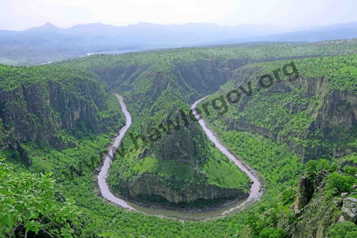
Small Zab (Lesser Zab)
It is one of an important river in Kurdistan region especially in Erbil, its fountainhead from west of Kurdistan mountain chain, particularly from Lahejan mountain in the east of Mahabad and near Hazna village which belong to Qaladzee District Dokan dam was built on its passage. In south of Kleesa village enter Erbil territory.Its length is about 400 km. and feedback to Tigris south of Makhmor near Shak Village.
Rezan Stream
Its one of Great zabs tributary originates from triangle border of Erbil, its a multiple small branches and Brazkr is an important one of them ,this stream pass to reach south east Rezan village and pour in Great zab .Its length is 64km.
Shamzeenan River (Ava Sheen)
Its one of Great zab tributary originated from Shamzeenan hills that enters Erbil city in the northwest boundary to be pour in Great zab south Balinda sub district .Its length is about 52 km.
Seedaakan Stream
Its fountainhead from Kelashen, Bzen, and Boleh mountains that meets a lot of streams to be two branches that connected each other in Doramlk village and continuing their passage toward Dyana plain to pour in Gali Ali bag .Its length is 58km.